Google DeepMind has unveiled a significant advancement in artificial intelligence, integrating its vast Street View dataset with Project Genie, a general-purpose world model capable of generating diverse, interactive environments. This pivotal development, announced during the Google I/O developer conference, marks a transformative step towards creating highly realistic and dynamic simulations of real-world locations, moving beyond static imagery to truly interactive virtual experiences. The integration promises to revolutionize applications ranging from robotics training and urban planning to immersive gaming and educational exploration, allowing users and AI agents alike to experience and manipulate digital representations of the physical world with unprecedented fidelity.
The Evolution of Immersive Digital Landscapes: From Static Imagery to Dynamic Worlds
For two decades, Google Street View has served as an unparalleled digital atlas, meticulously mapping the world’s thoroughfares, landmarks, and hidden corners. Launched in 2007, the initiative began by deploying camera-equipped cars, capturing panoramic street-level imagery across major U.S. cities. Over the years, its data collection methods expanded to include "tracker backpacks" for pedestrian areas, trikes for inaccessible paths, and even underwater apparatuses for marine environments. This monumental effort has amassed an astounding collection of over 280 billion images, spanning more than 110 countries and seven continents. For millions worldwide, Street View has become an indispensable tool, offering virtual journeys to childhood homes, enabling pre-trip reconnaissance of hotel neighborhoods in far-flung cities, or simply satisfying curiosity about distant locales.
However, the inherent limitation of Street View has always been its static nature. While providing a photographic snapshot of a moment in time, it lacked the dynamism and interactivity to truly simulate an environment. Users could navigate, but not manipulate; observe, but not interact. The vision of an interactive digital twin, where one could not only view a street but also alter its conditions—adjusting the weather, changing the season, or even projecting hypothetical scenarios like a "Day After Tomorrow" deluge—remained largely within the realm of science fiction.
Enter Project Genie, Google DeepMind’s ambitious endeavor into AI-driven world generation. First introduced as Genie 3 for research preview in August and subsequently opened to Google AI Ultra subscribers in the U.S. in January, Genie is a groundbreaking general-purpose world model designed to generate diverse, interactive environments from simple text prompts or images. Its core mission is to create adaptable virtual worlds for a multitude of purposes, from enriching educational experiences and fostering innovative gaming scenarios to providing sophisticated training grounds for advanced robotics. The underlying thesis of Genie, as articulated by Jack Parker-Holder, a research scientist on DeepMind’s open-endedness team, has always been its dual power: "really powerful for both the agent [and robotics] use case and for humans to play with."
The convergence of these two technological pillars—Street View’s unparalleled real-world data and Genie’s generative AI capabilities—represents a paradigm shift. As Parker-Holder aptly summarizes, "With Street View, we have imagery from a large quantity of the world. You can imagine how potentially powerful it is to combine this rich source of real-world information and data with an ability to simulate worlds." This integration bridges the gap between passive observation and active engagement, transforming billions of static images into living, breathing, and manipulable digital environments.
Unlocking New Realities: The Mechanism of Interactive Simulation
The integration allows Google DeepMind’s AI to process Street View’s vast photographic data and, through Project Genie, transform it into a three-dimensional, interactive environment. Imagine dropping the iconic Street View "little person icon" onto a specific street corner, not just to view it, but to step into a fully simulated version. Users will be able to alter environmental parameters dynamically, simulating a rainy afternoon in London, a snow-covered street in New York City during a different season, or even a flooded Parisian boulevard. This goes far beyond mere image manipulation; it involves the generation of consistent, explorable virtual worlds anchored to real-world geography.
A critical aspect of this technological leap is the AI’s ability to maintain spatial continuity. Jonathan Herbert, director of Google Maps, who began his career on the Street View team twelve years ago, highlights this as a key breakthrough. He notes that while Genie may not yet create a "faithful reconstruction" in terms of photorealism, its capacity for "spatial continuity" is revolutionary. When a user turns 360 degrees within a simulated environment, the AI accurately remembers and generates the surroundings, allowing for a coherent and consistent experience. From this foundation of spatial understanding, the model can then build new, dynamic elements and scenarios. This continuous understanding of space is fundamental to creating believable and explorable virtual environments that respond to user input.
Transformative Applications Across Industries
The implications of this Street View-Genie integration are profound and far-reaching, promising to disrupt numerous sectors:
-
Advanced Robotics and Autonomous Systems Training: This is arguably one of the most immediate and impactful applications. Training autonomous vehicles and robots in the real world is costly, time-consuming, and fraught with risk, especially for "exceedingly rare events." Project Genie, powered by Street View data, offers an ideal solution.
- Waymo’s Expansion: Waymo, Google’s autonomous driving company, already leverages Genie 3 in its simulators to train self-driving cars on infrequent occurrences like sudden tornadoes or unexpected elephant encounters. The addition of Street View data significantly enhances this capability. While Waymo has its own simulators, which have been instrumental in scaling to 11 U.S. cities, they are primarily car-centric. The Street View integration allows for the simulation of specific global cities with their unique urban complexities, diverse pedestrian behaviors, and varied infrastructure. Crucially, it also enables the shifting of the point of view beyond just the car, allowing for training from the perspective of other agents, such as pedestrians or service robots. This prepares Waymo for global deployment in a more nuanced and contextually rich manner.
- Robotics in Varied Environments: For general-purpose robots, the ability to simulate diverse real-world conditions is invaluable. Jack Parker-Holder provided the example of a new robot being deployed in London, a city not known for its abundant sunshine. Genie could simulate those rare moments when sunlight glints off Victorian architecture, preparing the robot’s sensors for such events and preventing "shocks" that could impair performance or cause errors. This goes beyond mere obstacle avoidance, delving into the nuanced environmental interactions crucial for robust AI agent deployment.
-
Urban Planning and Infrastructure Development: City planners and architects can utilize these immersive simulations to visualize future developments, assess environmental impacts, or test infrastructure changes before physical construction begins. Imagine simulating the impact of a new skyscraper on wind patterns, pedestrian flow, or sunlight exposure in a specific neighborhood, all within a dynamically adjustable digital twin of the city. This allows for iterative design and informed decision-making, potentially saving immense resources and mitigating unforeseen problems.
-
Immersive Gaming and Entertainment: The integration offers unprecedented opportunities for game developers to create highly realistic and geographically accurate game worlds. Players could explore simulated versions of real cities, engage in interactive narratives that unfold in recognizable locales, or even participate in educational games that teach about history or geography through immersive experiences. This blurs the lines between virtual and physical worlds, offering a new level of realism and engagement.
-
Education and Exploration: Students could embark on virtual field trips to ancient ruins, explore remote ecosystems, or witness historical events unfold in their actual geographical context. Researchers could simulate the effects of climate change, natural disasters, or urban growth on specific areas, gaining insights that would be impossible or impractical to obtain in the physical world. The ability to manipulate weather or time provides rich educational potential for understanding cause and effect in environmental and urban studies.
-
Accessibility and Tourism: Individuals with mobility challenges could virtually explore potential travel destinations, assessing routes and accessibility features before making physical journeys. Tourists could plan itineraries by experiencing simulated walks through neighborhoods, adjusting conditions to match their expected travel dates.
Current Limitations and the Road Ahead
Despite its groundbreaking potential, Google DeepMind’s Street View-Genie integration is still in its experimental phase, with acknowledged limitations that underscore the complexity of truly replicating reality. Diego Rivas, a product manager at DeepMind, cautions that both Street View in Genie and Genie generally remain experiments, with significant room for improvement, particularly in accuracy.
-
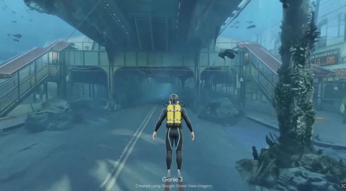
Photorealism vs. "Video Game Quality": While the initial samples shown by the Google team—including an underwater simulation of a familiar neighborhood—were impressive and recognizable, they currently exhibit a "video game quality" rather than full photorealism. The textures and lighting, while coherent, do not yet perfectly mimic real-world photographic fidelity. This is a common challenge in generative AI, where consistency and interactivity are often prioritized in early stages over pixel-perfect realism.
-
Lack of Physics Awareness: A more significant current hurdle is the models’ nascent understanding of real-world physics and cause-and-effect. In a demonstration of a woman running through a snowy Joshua Tree landscape, the simulation showed her passing directly through cacti and bushes without interaction. This highlights that the models are not yet "physics-aware" in an intuitive sense.
- This contrasts with other advanced Google AI models like Nano Banana, an image generator that can now render perfect text within infographics, or Veo, a video generator that intuitively understands physical phenomena—paper boats drifting on water currents, smoke dispersing naturally into the air, or fabric draping realistically over forms.
- The learning mechanism for these advanced physical understandings is not hard-coded but rather acquired intuitively over time through passive observation of vast datasets, much like a living being learns about the world. Parker-Holder is optimistic, estimating that this type of model is "maybe six to 12 months behind video in terms of the accuracy and quality," suggesting that significant advancements in physics simulation are anticipated in the near future.
The rollout strategy reflects this experimental stage. Access began today for some Ultra users in the United States, with a broader rollout to all U.S. Ultra users over time. Global Ultra users are expected to gain access within the next few weeks. This phased approach allows Google DeepMind to gather feedback, iterate on the technology, and address shortcomings as they scale.
Broader Implications: Towards the Digital Twin of Reality
The integration of Street View and Project Genie represents a significant stride towards realizing the long-held vision of creating comprehensive "digital twins" of the physical world. This goes beyond the concept of a "metaverse" as a purely fantastical realm; it envisions a practical, interactive, and functional digital replica of our planet, grounded in real-world data. Such a digital twin could serve as a powerful platform for scientific research, environmental monitoring, disaster preparedness, and even the future of commerce and social interaction.
Jonathan Herbert’s observation that Google has "long thought about how we can build out the best and richest model of the world on top of Street View data" underscores the strategic long-term vision guiding this development. This is not merely an incremental update but a foundational step in Google’s ambition to leverage its vast geospatial data in entirely new ways, driving the next generation of AI research and application.
As these AI models become increasingly sophisticated, capable of generating photorealistic, physics-aware, and highly interactive environments, the boundaries between the physical and digital realms will continue to blur. The ethical considerations around data privacy, the potential for synthetic media to influence perception, and the responsible deployment of such powerful simulation tools will become increasingly critical. Nevertheless, the integration of Street View with Project Genie opens up a future where our understanding, interaction with, and manipulation of the world, both real and virtual, are poised for an unprecedented transformation.