
Southeast Asia has solidified its position as a primary engine of the global travel industry, with the Association of Southeast Asian Nations (ASEAN) reporting that the region welcomed more than 143 million international visitors annually in the years immediately preceding the global pandemic. While traditional hubs such as Bangkok, Bali, and Ho Chi Minh City continue to dominate arrival statistics, a significant shift in traveler behavior is currently underway. Modern tourists are increasingly eschewing "bucket-list" mass tourism in favor of "slow travel" and "niche exploration," seeking destinations that offer deeper cultural immersion and ecological integrity. This transition highlights a growing demand for sites that remain relatively untouched by the commercial density of major urban centers. To understand the future of the region’s tourism economy, one must look toward the periphery—specifically to seven locations that represent the intersection of indigenous heritage, geological rarity, and sustainable development.
The Northern Frontier: Batanes and the Resilience of the Ivatan
Located at the northernmost tip of the Philippine archipelago, Batanes serves as a stark geographical departure from the tropical, palm-fringed imagery typically associated with the country. As the Philippines’ smallest province, Batanes is characterized by rugged coastal cliffs, rolling hills, and a temperate climate that bears a closer resemblance to the Highlands of Scotland or New Zealand than to the equatorial Pacific.
The region’s isolation—separated from the mainland by the turbulent Luzon Strait—has fostered a unique cultural evolution. The indigenous Ivatan people have developed a lifestyle centered on resilience and communal cooperation, known locally as kayvayvanaan. This is most visible in their architecture; traditional Ivatan houses are constructed from thick limestone walls and heavy cogon grass roofs, designed to withstand the frequent typhoons that sweep through the Bashi Channel.

Economically, Batanes has avoided the pitfalls of mass tourism through strict local regulations and a high cost of entry due to limited flight availability. This has preserved the integrity of sites like Sabtang Island, where the villages of Chavayan and Savidug offer a living museum of pre-colonial and Spanish-influenced heritage. Analysts suggest that the Batanes model of "high-value, low-impact" tourism serves as a blueprint for other remote provinces seeking to balance economic growth with cultural preservation.
Archaeological Sovereignty: Phnom Kulen National Park, Cambodia
While the Angkor Archaeological Park attracts millions of visitors to Cambodia each year, the historical narrative of the Khmer Empire begins nearly 40 kilometers to the northeast at Phnom Kulen National Park. Often referred to as the "Mountain of Lychees," this sandstone plateau is considered the most sacred mountain in Cambodia. It was here in 802 AD that Jayavarman II declared himself a chakravartin (universal monarch), marking the birth of the Khmer Empire.
Phnom Kulen is not merely a natural park but a massive archaeological site. Recent LIDAR (Light Detection and Ranging) surveys conducted between 2012 and 2015 revealed the hidden city of Mahendraparvata, an urban network that predates Angkor Wat by over three centuries. The park’s geography is defined by dense rainforests and the "River of a Thousand Lingas," where intricate carvings of Hindu deities remain submerged beneath the flowing water, intended to "bless" the river before it reaches the plains of Angkor.
The Cambodian Ministry of Environment has recently increased efforts to protect the park from illegal logging and encroachment. For the traveler, Phnom Kulen offers a transition from the manicured experience of Siem Reap to a more raw, exploratory form of archaeology. The park represents a critical link in the Khmer historical timeline, providing context for the architectural transition from mountain-based shrines to the massive stone temples of the plains.

Sustainable Alternatives: Bai Tu Long Bay, Vietnam
Vietnam’s Ha Long Bay is a UNESCO World Heritage site and a global icon, yet its popularity has led to significant environmental pressure, including water pollution and overcrowding. In response, savvy travelers and conservationists have turned their attention to the northeast: Bai Tu Long Bay. Geologically, Bai Tu Long is an extension of Ha Long, featuring the same spectacular limestone karsts and emerald waters, but it remains significantly less congested.
Bai Tu Long covers a vast area, including hundreds of islands within the Bai Tu Long National Park. The region is home to a diverse array of ecosystems, including mangroves, seagrass beds, and coral reefs. Unlike the high-density cruise traffic of its neighbor, Bai Tu Long is regulated to allow fewer vessels, many of which are boutique, luxury cruises that emphasize eco-friendly practices.
The presence of floating fishing villages, such as Vung Vieng, provides a window into a disappearing way of life. These communities have occupied the bay for generations, though the Vietnamese government has begun programs to relocate residents to the mainland to improve access to education and healthcare while reducing the environmental footprint on the bay. This transition makes the current period a critical time for witnessing the traditional maritime culture of the Tonkin Gulf in a tranquil setting.
The Crucible of Culture: George Town, Penang, Malaysia
George Town, the capital of the Malaysian island of Penang, stands as a testament to the complex colonial and mercantile history of the Malacca Strait. While many tourists visit Penang for its beach resorts, the inner city of George Town—a UNESCO World Heritage site since 2008—is the true draw for those interested in the convergence of Malay, Chinese, Indian, and European influences.

The city’s architecture is a "built history" of the British East India Company’s influence, interspersed with ornate Chinese clan houses (kongsi) and vibrant Hindu temples. The street food culture in George Town is arguably the most sophisticated in Southeast Asia, reflecting the "Peranakan" or Straits Chinese heritage—a fusion of Chinese ingredients with Malay spices and cooking techniques.
In the last decade, George Town has undergone a cultural renaissance fueled by the George Town Festival and a proliferation of street art, most notably the murals by Lithuanian artist Ernest Zacharevic. This has transformed the city into a hub for the creative class. From a journalistic perspective, George Town represents the successful "adaptive reuse" of heritage buildings, where 19th-century shophouses are converted into boutique hotels and galleries without destroying the city’s historical fabric.
Agrarian Heritage: The Bolaven Plateau, Laos
In southern Laos, the Bolaven Plateau offers a cool, high-altitude respite from the humid Mekong valley. Located in the Champasak Province, this volcanic plateau is the center of the Laotian coffee industry. The French introduced Arabica and Robusta trees to the region in the 1920s, taking advantage of the rich volcanic soil and the elevation, which ranges from 1,000 to 1,350 meters.
The Bolaven Plateau is defined by its dramatic waterfalls, such as Tad Fane and Tad Yuang, which plunge hundreds of meters into lush gorges. However, the plateau’s true depth lies in its ethnic diversity. It is home to various Mon-Khmer speaking groups, including the Laven (from whom the plateau takes its name), Alak, and Katu. These communities are central to the region’s burgeoning "agritourism" sector.

The "Coffee Loop"—a popular motorbike route—allows visitors to engage directly with small-scale farmers. This form of tourism provides essential supplementary income to local families and incentivizes the preservation of traditional organic farming methods. As Laos continues to develop its infrastructure, including the new high-speed railway, the Bolaven Plateau is positioned to become a major destination for travelers seeking an intersection of adventure and sustainable agriculture.
The Royal Canopy: Doi Inthanon National Park, Thailand
Known as "The Roof of Thailand," Doi Inthanon National Park is home to the country’s highest peak, rising 2,565 meters above sea level. Located in the northern province of Chiang Mai, the park is a vital sanctuary for biodiversity, serving as a habitat for more species of birds than almost anywhere else in mainland Southeast Asia.
The park is notable not only for its natural beauty—including the mist-shrouded cloud forests and the cascading Wachirathan Falls—but also for the "Royal Projects." Initiated by the late King Bhumibol Adulyadej, these projects were designed to eliminate opium cultivation among hill-tribe communities by replacing it with high-value temperate crops like strawberries, coffee, and flowers. Today, these projects have transformed the local economy, creating a sustainable model of mountain development.
The Twin Pagodas, built to honor the 60th birthdays of King Bhumibol and Queen Sirikit, offer panoramic views of the Himalayan foothills. For the modern traveler, Doi Inthanon represents a sophisticated blend of conservation and national identity, where the protection of the watershed is inextricably linked to the welfare of the indigenous Karen and Hmong people who reside within the park’s boundaries.

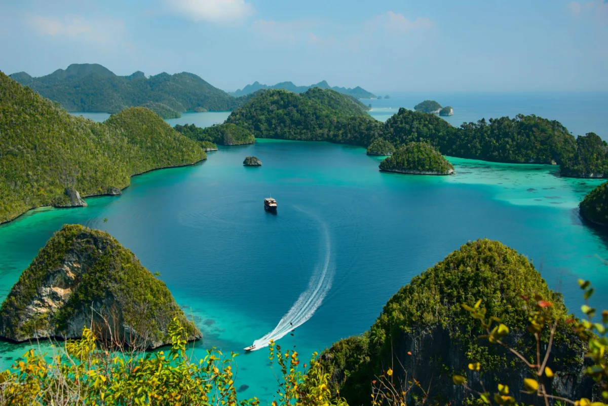
The Last Frontier: Raja Ampat, Indonesia
Raja Ampat, or the "Four Kings," is an archipelago of over 1,500 islands located off the coast of West Papua, Indonesia. In the realm of marine biology, it is considered the most biodiverse marine habitat on Earth. Situated in the heart of the Coral Triangle, Raja Ampat contains approximately 75% of the world’s known coral species and over 1,400 species of fish.
The region’s remote location has acted as a natural barrier against the over-development seen in other parts of Indonesia. Conservation efforts here are some of the most successful in the world, largely due to the "MPA" (Marine Protected Area) network and the involvement of local communities in patrolling the reefs. The Misool Marine Reserve, for instance, has seen a 250% increase in fish biomass over the last decade due to strict no-take zones.
Tourism in Raja Ampat is primarily centered on diving and snorkeling, with "liveaboard" vessels being the preferred mode of transport for exploring the distant reaches of the archipelago. However, the rise of eco-resorts and homestays is allowing for more land-based interaction. The high cost of the "Marine Park Entry Permit" is a deliberate policy to ensure that tourism revenue is reinvested into conservation and local healthcare, making Raja Ampat a global gold standard for high-end, sustainable eco-tourism.
Implications for the Regional Tourism Economy
The emergence of these seven "hidden wonders" signifies a broader maturation of the Southeast Asian travel market. As infrastructure improves—including regional airports and better road networks—these formerly inaccessible areas are becoming viable alternatives to overcrowded hubs.

The economic implications are significant. By diversifying tourism destinations, countries can distribute wealth more equitably to rural and indigenous populations, reducing the urban migration pressure on cities like Manila, Hanoi, and Bangkok. Furthermore, these sites emphasize "quality over quantity," attracting a demographic of travelers who stay longer and spend more per capita on local services.
However, this transition also presents challenges. The primary risk is that the very "untouched" nature that draws visitors to Batanes or Raja Ampat may be eroded by the infrastructure required to host them. The success of these destinations will ultimately depend on the ability of local governments to enforce carrying capacities and environmental regulations. As Southeast Asia looks toward the next decade of growth, the management of these seven gems will likely determine whether the region can successfully pivot from a model of mass consumption to one of sustainable, long-term stewardship.